Map for Day 1. Day 2 is easier to follow
Difficulty : Advanced
Altitude : 3257m
Itinerary : two possible itineraries, ca be done in one or two days.
As I did only the two day version, I’ll only summarize the one-day option.
The one-day track must be started quite early as the maximum total duration of average hikers is of 10h round trip for >13 km. The one day hike starts in Van d’en Haut. You can reach that place by car or by bus. The first part is a steep hike up of 1h30 to reach the mountain hut of Salanfe. That hut is located right next to the lac of Salanfe and offers a stunning view on 4 main mountain peaks. It’s also a great place to eat lunch!
From there you can reach Mont Luisin, a beautiful summit that will take you around 2h30 (one way) for 4.6 km. You can learn more with my previous post on that topic.
We took a different start.
We started from Grand Paradis and left the car there. From there, the one way hike takes 12 h for 23 km and 2605 elevation gain.
We spent the first day hiking from Grand Paradis to the Refuge of Susanfe.
The best thing is to park at the very end of the road, along the river (close to the trash collecting area – (P) on the map). The beginning of the trail is located in the forest, after the road and is indicated with a yellow arrow. The first part consists of steep elevation gain until you reach the end of the “Bonavau” forest. From there you will have a “semi-flat” part until you reach the Bonavau mountain hut.
On that trail you will cross a beautiful suspended bridge.
Once you reach the intersection between Bonavau hut and “Pas d’Encel”, follow the path for Pas d’Encel. From there on you will have again an important elevation gain followed by a beautiful yet tricky mountain pass. The Pas D’Encel is not an easy passage as you will have to use the chains along the path to stay safe. There will be some passages with important vertical drop. Take your time, don’t run.
After that passage, you will arrive at the bottom part of the Susanfe valley. That valley will stretch all the way up to the basis of the Dents du Midi.
From there, the hike will be simpler, through a beautiful valley towered by two mountain chains.

If you are lucky, there will be sheeps (which was a big plus for us ^^)
We spent the night at the hut, got a good meal and rested for the next day that will be quite more demanding.

The night was tough as I forgot my ear plugs and eye shader (if that is actually the name for it ^^). You spend the night in a mass dorm (no group rooms).
People are leaving quite early and just turn on their flashlights full power to find their way through the dorm which was super annoying.
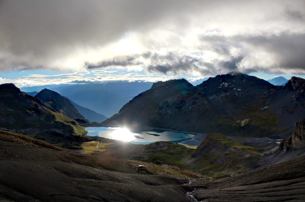
Early morning, we left at 6 the hut and made our way up towards the top of Susanfe valley. We were slightly skeptical as the weather was extremely cloudy and foggy. As the weather forecast still predicted sun for 11 am we kept walking in the direction of the Susanfe pass. With our progress, the fog raised slightly, offering us a breathtaking view over Salanfe’s lake with a beautiful sun, rising and reflecting on it. Nevertheless, the weather was still foggy but we decided to keep going up “Haute Cime” as the weather predictions should be correct that day.
We spent the whole first part till the “Col des Paresseux” in a very thick fog. Most of the people we met on our way (those who woke up and left earlier) were turning around because the visibility was terrible and the trail relatively steep and slippery.

I must say that the section between Col de Susanfe and Haue Cime is the steepest and most dangerous section of your trek. If you don’t feel it, don’t do it. Reaching the Col des Paresseux is already a great achievement and as the name indicates, it is where usually people turn around as the next part will get steeper again.
While we arrived at the Col des Paresseux, the weather was getting better and the fog slowly dissipating. It actually completely disappeared by the time we made it to the summit.

The last part was stunning. We spent a couple of hours up there while having lunch. After a while we took exactly the same way down and made one straight hike to the parking area.
The way down was long. Beautiful and satisfying yet tiring ;D but it was an amazing journey and a beautiful place to discover.
A more descriptive itinerary can be found here
Find all the possible hikes in that area here
Looking for other hiking or travel destinations? Check here!
Looking for other places to stay ? check here!
Or do you simply have a question? Contact me!